
Field research on the Georgia coast in August can be challenging. Just ask Courtney Balling, a graduate student studying crop and soil sciences at the University of Georgia.
“I don’t know if you’ve ever tried to walk out into our marshes, but you can easily sink up to your waist,” says Balling. “It’s not the easiest place to work.”
This is one reason Balling is excited to use innovative drone technology for her research on living shorelines.
As part of her Public Service and Outreach Graduate Assistantship with Marine Extension and Georgia Sea Grant, Balling is comparing bulkheads to living shorelines and studying the effect of these stabilization methods on adjacent properties.
“Our hypothesis is that living shorelines will have less of an impact in terms of erosion at neighboring shorelines than bulkheads, which may cause more erosion,” Balling says.
A living shoreline involves the use of natural materials, like oysters or native vegetation, to stabilize estuarine shorelines. In many settings, living shorelines provide an effective means of long-term shoreline stabilization by buffering wave energy, trapping sediments, providing habitat and maintaining a connection between the marsh and upland habitat.
“There’s a lot of research on the ecological benefits of living shorelines, but not a lot on how they function physically,” Balling says.
Balling is using different methods to measure erosion rates, including collaborating with Marguerite Madden, director of UGA’s Center for Geospatial Research (CGR). She and Madden enlisted the help of drone pilot and former associate director of CGR, Tommy Jordan, to fly drones above the study sites to collect high-resolution images. Madden then creates fine scale three-dimensional models by overlapping the images. This technique is called Structure from Motion technology.
“With the drone, you can cover large expanses at a lower cost than you normally would with conventional mapping technology,” says Balling. “I’m really interested in low cost methods because I think it opens up science to different communities and people that might not have access.”
Other benefits of Structure from Motion technology include speed and accuracy. Balling explains that flyovers at each site only take half an hour, whereas traditional methods used to study erosion, such as using a laser scanner or taking fine scale GPS points along the shoreline, might take up to three or four hours.
Over the course of the study, Balling will assess how living shorelines and bulkheads behave during routine events, like the daily tidal cycle, as well as how they function during major events like hurricanes. When Hurricane Irma hit the east coast in mid-September, it caused storm surge and flooding on the Georgia coast, particularly in areas where Balling’s research sites are located.
During her first post-Irma trip to the coast, Balling was surprised at how much erosion she observed.
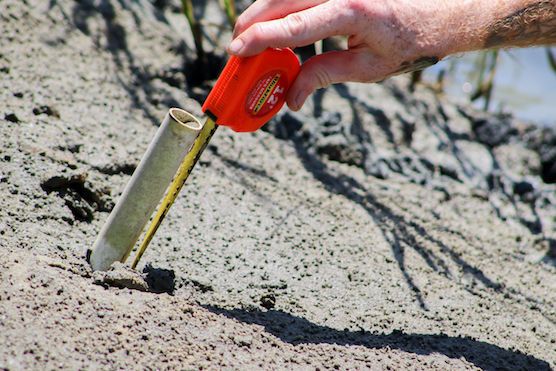
“There was so much change after Irma that we realized erosion pins aren’t necessarily capturing everything,” says Balling. Erosion pins are PVC poles placed every five meters in the bank of the shoreline. They serve as points of reference that are measured during each site visit.
“It really drove home how much more information we’re going to get from the 3D models in terms of accuracy.”
Once the data collection phase is complete, several 3D models created using the drone imagery will be overlayed on top of one another.
“Our plan is to look at the different 3D models and calculate the volume of sediment lost or gained at different areas along the streambank,” says Balling. “Traditionally, coastal erosion studies look at 2D shoreline position change. The volumetric data we’re able to get using the 3D models is what will make the data so valuable. ”
This information will be shared with the Living Shorelines Working Group, which includes researchers, resource managers and decision makers who are studying living shorelines in Georgia, South Carolina, Florida and North Carolina. Balling also plans to share her findings with the Georgia Department of Natural Resources Coastal Resource Division to help inform permitting and policy assessments of living shorelines in Georgia.
“Not only do I want to increase our knowledge of the functionality of living shorelines, I also want to be able to give managers an idea of how the SfM method works and the level of accuracy you can obtain using this method,” says Balling.